|
|
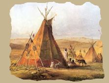
The Omaha - The Pawnee - The Otoe
The Santee Sioux - The Winnebago
The Ponca - The Iowa and The Sac and Fox In 1854, when Nebraska was admitted into the Union, there were, as nearly as can be estimated, 10,000 Indians on reservation & in the Territory, the greater portion of them living in the eastern part, in permanent villages, along the Missouri and Platte Rivers, and their tributaries, while in the northwestern part there were several
roving bands of the great Sioux nation, of whom those in the eastern part stood in mortal fear.
The Omaha
Numbering between 900 and 1,000 at that time, occupied the country lying along the Missouri, extending from the mouth of the Platte River, northward to the old Council Bluffs of Lewis and Clarke, in Washington County, and westward some forty miles. Their main villages were at Bellevue (Sarpy County) and Saling's Grove, on the Big Papillion, eight miles distant, where they had lived most of the time since 1830.
The Omaha are a tribe of the Dakota family. Marquette represents them on his map in 1673, and about 1766 Cover found them on the St. Peter's, where they formed two tribes - the Hongashanos and the Ishbanondas, or Grey Eyes - divided into thirteen clans, one of which preserved a sacred shell in a rude temple, constantly guarded. They cultivated corn, beans and melons.
Among their customs was one preventing a man from speaking with his father-in-law or mother-in- law. Just what length of time this tribe was known on the Missouri is difficult to ascertain, but somewhere about the year 1780, they crossed over the country from the Upper Lakes and settled on the Missouri, at or near the mouth of the Big Sioux River, in Iowa, at which time there was a band of Cheyenne with them. Shortly afterward they crossed to the west side of the
Missouri and settled on the Niobrara, near its mouth, at which place Lewis and Clarke found them in June, 1804, numbering about 600. Being pursued relentlessly by the Sioux, and greatly reduced in numbers by small-pox, they burned their village on the Niobrara and removed to the Blackbird hills, about 100 miles further down the Missouri, where they have resided at times for more than half a century. Treaties were made with them on July 20th, 1815, September 23d,
1825, and July 15th, 1830, ceding lands at Council Bluffs for an annuity, blacksmith shop and agricultural implements.
After this last treaty they formed their villages at Bellevue, near the trading post of Colonel Peter A. Sarpy, and at Saling's Grove, where they remained until June, 1855. The Sioux frequently drove them to the Elkhorn River, but in 1843 they returned to their villages and made peace with certain bands of the Sioux. A mission begun in 1839 failed, and one established in 1846, had but little success. By treaty of March 16, 1854, more of their lands were ceded, and
in the following year they were removed to their present reservation of 345,000 acres in the northeastern part of the State, between the Missouri and Elkhorn Rivers. Since then they have devoted themselves to agriculture, and their condition has rapidly improved. In 1879 they numbered about 1,050. Their Great Chief, Logan Fontenelle, was killed by the Sioux while on a hunting expedition, in July, 1855.
The Pawnee
In 1854, lived on the south bank of the Platte River, their main village being a few miles east of where Fremont now stands. They numbered then between 4,000 and 5,000. They had been residents, of Nebraska for a century or more, and are spoken of by both Spanish and French explorers as being a warlike and powerful nation, and the most numerous of any west of the Missouri. They were first heard of through the Illinois, and the name is of that language. Marquette
noted several bands on his map in 1673. They were hostile toward the Spaniards but have always been friendly toward the Americans. Their first stopping place on the west side of the Missouri River seems to have been at the confluence of the Republican, which place they soon abandoned, however, moving a considerable distance up the latter stream, where they established a large permanent village of earth-covered lodges, and cultivated corn, beans and melons,
frequently going of to the buffalo lands to hunt and meet their enemies in warfare. They claimed the country south to the Kansas River and north to the Platte. Pike, in 1806, estimated the population of three villages at 6,223, with two thousand warriors. They were divided into four bands - Tswa (Grand Pawnee), Tskithka Petower Kattahankies (Republican Pawnee), Tapage Pawnee and Sker Pawnee, Mahas or Loups. They were constantly at war with the Sioux and other
tribes. From time to time they sacrificed prisoners to the sun to obtain good crops and success in warfare. Anyone was at liberty to offer up a prisoner that they had captured in warfare. The victim was clothed in the gayest apparel and fed and feasted on the best that could be had, and when sufficiently fattened for their purpose, a suitable day was appointed for the sacrifice, so that the whole nation might attend. The unfortunate victim was then bound to a
cross in the presence of the assembled multitude, after which a solemn dance and other ceremonies were performed, and at their conclusion the warrior whose prisoner he had been, stepped forward and cleaved his head with a tomahawk, the other warriors filling his body with arrows. This barbarous custom, however, was finally stopped in 1820, through the influence of the missionaries.
The removal of the Delaware to lands between the Platte and Kansas Rivers led to a war with that tribe, who, in 1832, burned the great Pawnee village on the Republican River. They then removed to the Platte, in the present Butler County, where small-pox carried off large numbers of them. By treaty of October 9th, 1832, they sold lands south and agreed to remain north of that river and west of the Loup River. Provisions were then made for education and they were
soon possessed of comfortable homes, good farms and schools, but all this was checked by the Sioux, who attacked them in their hunts, killing many, and finally invading their villages, burning them and killing men, women and children, and driving them south to the Kansas River. The Government regarded this as a violation of their treaty and stopped their annuities, their missionaries and farmers left them, cholera and smallpox swept off hundreds, and in three or
four years they had lost one half of their number. Returning again to the Platte, they resided for any years at the junction of Salt Creek with that stream near where Ashland now stands.
By treaty of September 4th, 1857, they sold more of their lands and were soon afterward removed to their reservation in the valley of the Loup Fork River, containing 288,000 acres. In June, 1861, they numbered 3,414, and furnished the government a sufficient number of scouts for the Indian war of 1864, on the plains. This increased the hostility of the Sioux, who, after making peace with the government, turned again on the wretched Pawnees, slaughtering them
without mercy, and effectually stopping their progress and improvements. By act of Congress June 10th, 1872, 118,424 acres were sold for their benefit, the grasshoppers having destroyed their crops. On October 8th, 1874, the Pawnees in general council agreed to remove to a reservation in the Indian Territory, where they were taken in the following year. They have a perpetual annuity of $30,000, with an appropriation for education, farming, etc., of $22,600 more.
There is no grammar [sic] or vocabulary of their language.
The Otoe
In 1854, occupied the south eastern portion of the State, south of the Platte River, their hunting grounds extending as far west as the Blue. They numbered at that time between 800 and 1,000, all told, and their principal village was a few miles below the present Nebraska City.
The Otoe belong to the Dakota family and were originally a part of the Missouris, with whom they have been for years united, forming one village. They were known to the French in 1673 under the name of Attanka, and calling themselves Wahoohtahta. Major Long, who explored this country in 1819-20, says the Otoe were a band from a great nation living at the head of the Mississippi River, from whom they separated in about 1724, coming west to the Missouri, their first
settlement in Nebraska being near the mouth of the Great Nemaha River. Their next camping ground was on the Platte, fifteen or twenty miles from its mouth, and it was from this camp that several of their Chiefs and warriors went to visit and hold a council with Lewis and Clarke in the summer of 1804, at the latter's camp on the bluffs of the Missouri sixteen miles above Omaha, from which incident the place derived its name of Council Bluffs. From the Platte they
came to the Missouri and established villages on the plateau now occupied by the city of Omaha, where they were living in 1820, but removed shortly afterward again to the Platte, near their old homes.
Abandoning this place they established permanent villages of earth-covered huts on the Missouri a few miles south of the present location of Nebraska City, where they were living at the time of the opening up of the Territory to settlement. Treaties were made with them on June 24th, 1817, and September 26th, 1825, and by treaty on March 15th, 1854, the confederated tribes of Otoe and Missouris ceded their rights to the lands lying along the Missouri, and were
removed to a reservation of 16,000 acres on the southeastern border of the State, where they still remain; both tribes, together, in 1879, numbering less than five hundred souls. The western half of their reservation has been appraised for sale.
The Santee Sioux
About eight hundred in number (1879), are located in Knox County on the Missouri River, near the mouth of the Niobrara, on a reservation of 115,200 acres, of which one-fourth is adapted to tillage, and nearly all the rest suitable for grazing. These Indians wear citizens' dress and are the most civilized of all the Sioux. They have five schools under the care of the Episcopalians.
Winnebago
The Winnebago, a tribe of the Dakota family, live on a reservation of 128,000 acres at the Black Bird hills, on the Missouri River, in the northeastern part of the State, north of and adjoining the Omaha reservation, and numbered, in 1879, about 1,650. They lived in Wisconsin and Minnesota in 1793. After being defeated by Wayne they made peace with the Government, but in the war of 1812 took sides with the English. After several treaties being made with them at
different times, they were removed in April, 1863, to Crow Creek, in Dakota, above Fort Randall. The place was entirely unsuited to them, affording no means of livelihood or support, and surrounded by hostile tribes of Indians. Deaths were so numerous from disease, war and famine, that out of 1,985 but 1,222 were left.
They left and succeeded in reaching the Omaha reservation, and appealed for shelter. In May, 1866, they removed to Winnebago where all had to commence anew. In June, 1869, they were assigned to the care of Friends. They are a quiet, peaceable people, wearing citizens' clothing, electing Chiefs annually, and preserving order by means of an Indian Police. Lands were allotted to such as wanted to take up farms, and in 1871, they numbered 1,445, with farms, cottages,
stock, and three day schools. On their removal from Minnesota, 160 half-breeds, who had taken land, remained, and these received as tribal share $800, but many have lost this and lands, and have joined the tribe in Nebraska. In the winter of 1874 they numbered nearly 1,000. Most of these were removed to a small tract purchased for them near the Winnebago reservation, but many of them left almost as soon as they reached it. Attempts by the Catholics and
Presbyterians to bring them back met with little success.
Ponca
The Ponca resided for many years on a reservation near the mouth of the Niobrara River, in Dakota Territory. They were originally a branch of the Maha or Omaha, and resided on the Red River of the North. Here they were attacked by the Sioux, and after losing greatly, removed to the opposite side of the Missouri and built a fortified village on the Ponca River. They united with the Omaha but have generally kept apart. Their constant pursuit by the Sioux kept them
wandering until reduced to a wretched condition. At the beginning of this century their number was very small, but after the coming of Lewis and Clarke and the treaty of June 28, 1817, and June 9, 1825, they improved rapidly, and in 1832 they numbered 750, a large majority of which were women. On March 12,1858, they sold their lands to the Government and went on a reservation near the Yankton, the compensation to be in installments of $185,000, with the support of
schools and agricultural aid. But their crops failed and they were harassed and killed by the Sioux. A new treaty March 10th, 1865, gave them a reservation of 576,000 acres of bottom land near the junction of the Niobrara, in Dakota, where they formed three villages. In the distribution of Agents the Ponca were assigned to the Protestant Episcopal Church, and soldiers were sent in 1874 to protect them. They then numbered 730, and 132 half-breeds. They are an
inoffensive, agriculturally disposed people, speaking the same language as the Omaha.
In 1877, the Ponca were removed to a reservation in the Indian Territory.
In 1879, thirty of these Indians, with Standing Bear, their Chief, left their Reservation, and returned to the Omaha Reservation, where they remained until a detachment of soldiers were ordered to take them back. On arriving at Omaha, under arrest, by order of the Interior Department, in charge of soldiers, a writ of habeas corpus was sued out, and heard before Judge Dundy, of the United States Court, where Hon. A. J. Poppleton and J. L. Webster, volunteered their
services on behalf of the Indians, which came on in Court May 2d, and after a careful hearing, they were released from custody. They returned to the Omaha Reservation. The question, however, is still pending in the U. S. Courts.
On June 3d, U. S. Court, Prosecuting Attorney presented the case before Judge Miller, who decided he had no jurisdiction over the Ponca prisoners released by Judge Dundy, on a writ of habeas corpus, as they were not in Court, but would continue the case in order to give Prosecuting Attorney Lambertson time to investigate further. The Indians, however, are at liberty.
Iowa, and Sac and Fox
The Iowas, and Sacs and Fox Indians occupy a reservation of 32,000 acres in the south-eastern corner of the State, extending over into Kansas.
In 1879 the Iowas numbered about 250, and the Sacs and Fox 100.
The Iowas are a tribe of the Dakota family, and were called Pahucha -- dirty nose, -- and by some, Grey Eyes, or Iowas. Marquette, in 1673, lays them down as the Pahoutet, living back of the Des Moines River, and consisting of eight clans - the Eagle, Wolf, Bear and Buffalo, which are still in existence, and the Pigeon, Elk, Beaver and Snake, now extinct, - each clan being distinguished by a peculiar way of cutting the hair. The Iowas, numbering 992 in 1824, were
removed. by treaty of September 17, 1836, and placed on the Missouri, above Wolf River, but a part broke off the next year and became vagrants, living by theft and hunting on grounds of other tribes. A Presbyterian mission and labor school earnestly maintained from 1835 to 1866, failed to save this people, and in 1846 they had declined to 706. By treaty of March 6, 1861, the tribe, reduced to 305 souls, ceded all but a reservation of 16,000 acres; in 1869 they
agreed to sell this and remove, but retracted, giving part to the Sacs, who actually sold their reservation. In 1872 they numbered 225, and were quite favorable to the school, which had sixty-three pupils. They dress in civilized garb, have a number of good frame and log houses, and cultivate several hundred acres of land, while the value of their stock is about $8,000. The United States holds $57,500 in trust for them, the interest of which is paid annually to
heads of families.
The Sacs and Fox have long been united, forming one band. In 1822 they lived on the Mississippi River, near Fort Armstrong, and are spoken of as being expert hunters and canoe men. They cultivated corn, beans and melons. and a few were employed in the lead mines near Galena, Ill. Treaties were made on August 4, 1824, and July 15, 1830, in which they ceded lands. They were to some extent involved in the Black Hawk war of 1831, at the close of which the two tribes
made a treaty at Ft. Armstrong with General Scott and Governor Reynolds, ceding lands for an annuity of $20,000 for twenty years, and by a subsequent treaty at Rock Island, a part reserved in the last embracing 256,000 acres, for $192,000. They then settled on the Des Moines River, Iowa, on an irregular square tract about 140 miles each way; the Foxes at this time numbering 2,446. Government removed them again by treaty in 1842, and in 1849 they were chiefly on
the Osage. Since then in spite of the Government's efforts to civilize and improve them, they have declined in numbers very rapidly, rejecting with a steady persistency missionaries and schools. The united Sacs and Fox in 1822 numbered 8,000, but were reduced in 1874 to 1,135, of whom 500 were in the Indian Territory, 338 in Iowa, 200 in Kansas, and ninety-seven on their reservation of 16,000 acres in the southeastern part of Nebraska, adjoining that of the Iowas.
They have an annuity of $10,506.
This site includes some historical
materials that may imply negative stereotypes reflecting the culture or language
of a particular period or place. These items are presented as part of the
historical record and should not be interpreted to mean that the WebMasters in
any way endorse the stereotypes implied. Johnson's History of Nebraska, 1880
Native American Nations
 |